Supporting ocean and shoreline planning in Washington
Challenge

The State of Washington enacted legislation for marine spatial planning in March 2010 identifying renewable offshore energy and marine conservation as primary management objectives. It was understood that community engagement and access to data would be critical to its success. A timeline and budget for the process however was not established.
While the state was starting to prepare for marine spatial planning, the Marine Resource Committee of Pacific County expressed interest in a planning tool to assist in updating their Shoreline Master Plan. Specifically, county officials wanted to refine their shoreline inventory and identify places where there are real or potential conflicts between shoreline land use and important marine resources.
Both the State of Washington and Pacific County communicated a common objective of engaging stakeholders and interest groups to contribute directly to ocean management decisions, and both governments recognized the ability for coastal marine spatial planning to achieve that.
Approach
The Nature Conservancy and Ecotrust saw that the kind of engagement needed by these groups could be facilitated with features provided by the Madrona framework. Together, they proposed the development of Washington Marine Planner, a tool that could consider multiple planning objectives and their associated tradeoffs. Traditionally, this would be an information management challenge, but scenario planning and tradeoff analysis features were readily integrated with existing Madrona features for data visualization and group collaboration.
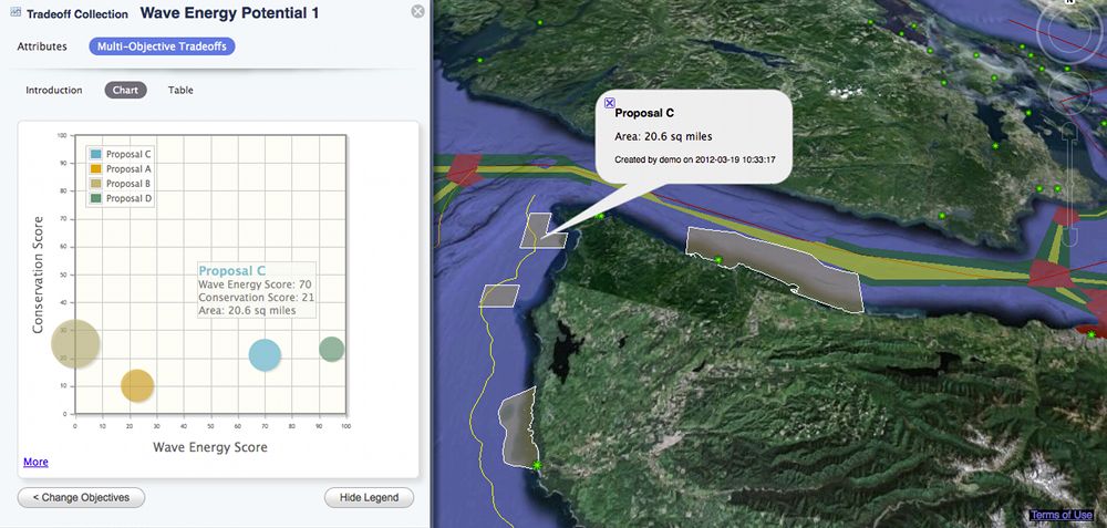 Multi-objective tradeoff analysis
Washington Marine Planner was successfully released in March 2012 as part of a pilot project designed to familiarize people in the state of Washington with marine spatial planning. The planner provided a platform for data integration, scenario planning, exploring good spatial design and addressing trade-offs between management objectives. The tool makes available a variety of local and regional datasets on coastal, nearshore and offshore marine environments, and it allows Pacific County to weigh priority issues including beach erosion, aquaculture, public access, shoreline uses, and water quality improvements.
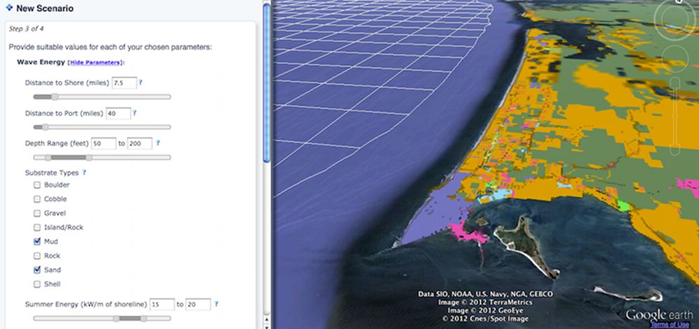 Multi-objective scenario planning
Notable Features
- Extensive set of data layers for viewing and analysis
- Site design with feature sketching
- Suitability/scenario analysis
- Multi-objective tradeoff analysis
- Group collaboration and sharing
Technology
- Madrona framework
- Google Earth web plugin
- Grass GIS
- Starspan
- JQPlot
- Arc2Earth
- Amazon Elastic Cloud Computing and S3 storage
Links
- Learn More
- http://www.marineplanning.org/Policy/USA_WA_MarinePlanner.html
- Application
- http://washington.marineplanning.org/
- Source code
- http://code.google.com/p/washington-marinemap
Contact
For more information, contact Charles Steinbeck at - (503) 467-0777. Or contact Zach Ferdana at - (206) 343-4345 x343.